Fishing closures
Fishing closures may be permanent, seasonal or temporary. Closed areas help replenish fish numbers by:
- protecting fished species during their breeding season
- letting juvenile fish grow in safety
- reducing fishing pressure on stocks.
You must return any species you catch during a closure period to the water immediately.
Closure maps
Learn about viewing GPS, Google Earth and Google Maps data, including disclaimers and accuracy statements.

See closures in one simple map
The free SA Fishing app has all the information you need to fish in state waters. This includes a GPS map highlighting the fishing closures.
Download the SA Fishing appAreas closed to all fishing
All fishing activity is strictly prohibited within these areas during closure times.
Fishing is banned in some areas all year. You cannot enter some areas during closure periods.
Within the inner waterways of the Port Adelaide River system, southeast of a line from Pelican Point to the southern breakwater at St Kilda, it is not permitted to:
- use a fishing line (hand line or rod) within 50 metres of a visible dolphin
- use hooks with a shank length greater than 56 mm and a gape greater than 23 mm.
View the map of the impacted area ( ).
Areas of the Adelaide Dolphin Sanctuary are located within the Barker Inlet – St Kilda Aquatic Reserve where additional restrictions apply – see gear restricted areas.
No entry: 1 May 2022 to 31 October
This is a seasonal mammal protection zone. Vessels cannot enter the area during the closure time.
Find more access and use information via Australian Marine Parks.
Permanent fishing closure
You must not fish in the area within 25 metres of any part of Horseshoe Reef that becomes exposed at low tide.
Horseshoe reef is located nearby Christies Beach. (35°8′14.6″ South, 138°27′49.1″ East).
Permanent fishing closure
You must not fish or take anything from a national park zone including:
- marine animals
- plants
- seagrass
- shells.
Find more national marine park access and use information via Australian Marine Parks.
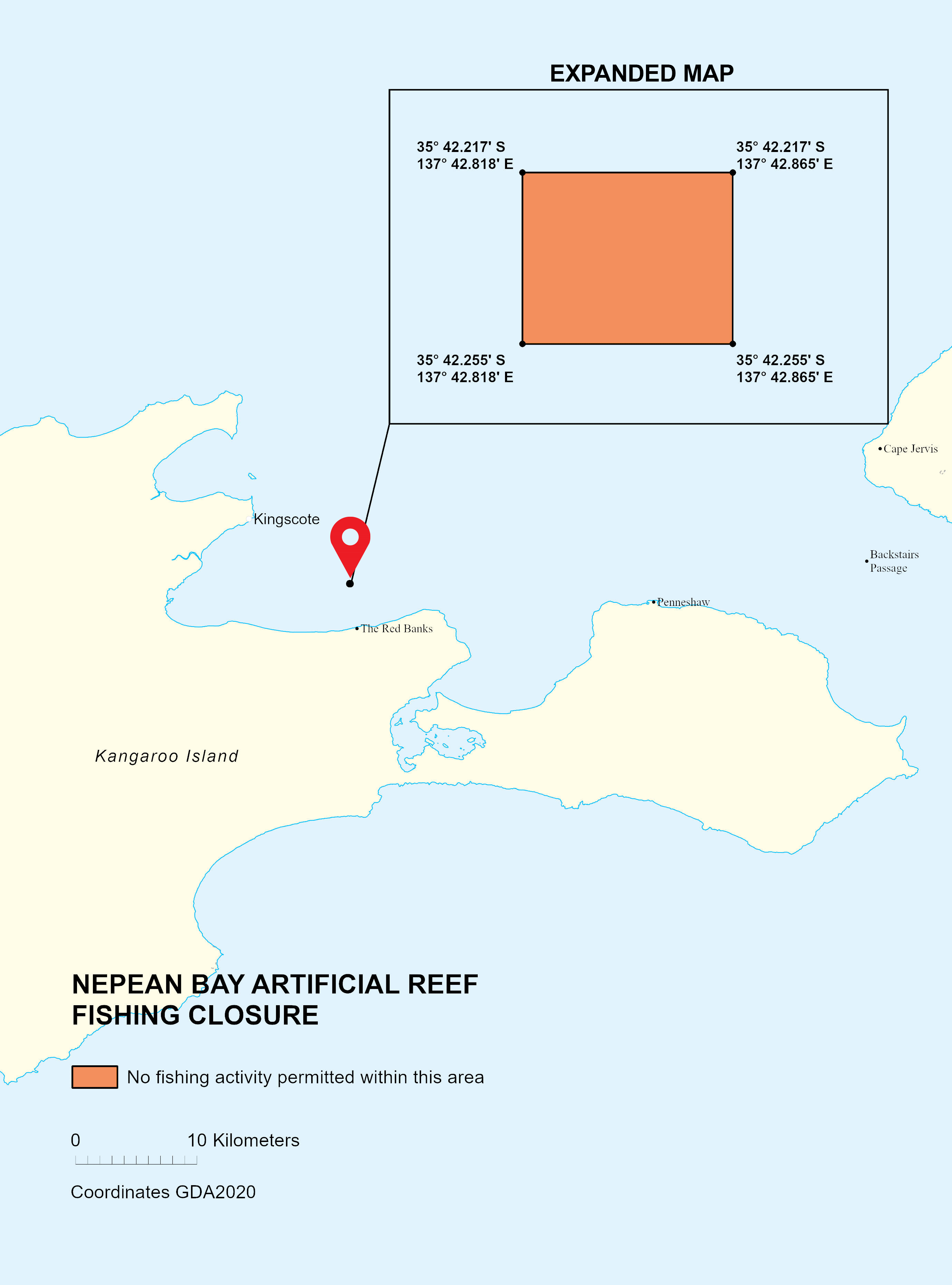
The Nepean Bay artificial reef will provide habitat for important recreational species and enhanced recreational fishing opportunities in the future.
All fishing is temporarily prohibited from 25 May 2026 for 12 months while the reef establishes:
- no fishing activity of any kind, including line fishing, crab netting and spearfishing
- no collection or removal of any bottom dwelling organisms such as oysters, seaweed, crabs or other shellfish.
Boating and diving is permitted.
The closure area is 70 metres by 70 metres, bounded by these points:
- 35° 42.217' S, 137° 42.818' E
- 35° 42.217' S, 137° 42.865' E
- 35° 42.255' S, 137° 42.865' E
- 35° 42.255' S, 137° 42.818' E
Permanent fishing closure
You must not fish within 150 m of all locks and weirs in the River Murray.
South Australian marine parks are divided into zones. Permanent, temporary and seasonal closures apply within these different areas.
You must not fish or take anything from sanctuary zones, including:
- marine animals
- plants
- seagrass
- shells.
You must not enter any restricted access zones.
Find marine park zone information, maps, and coordinates via National Parks and Wildlife Service South Australia.
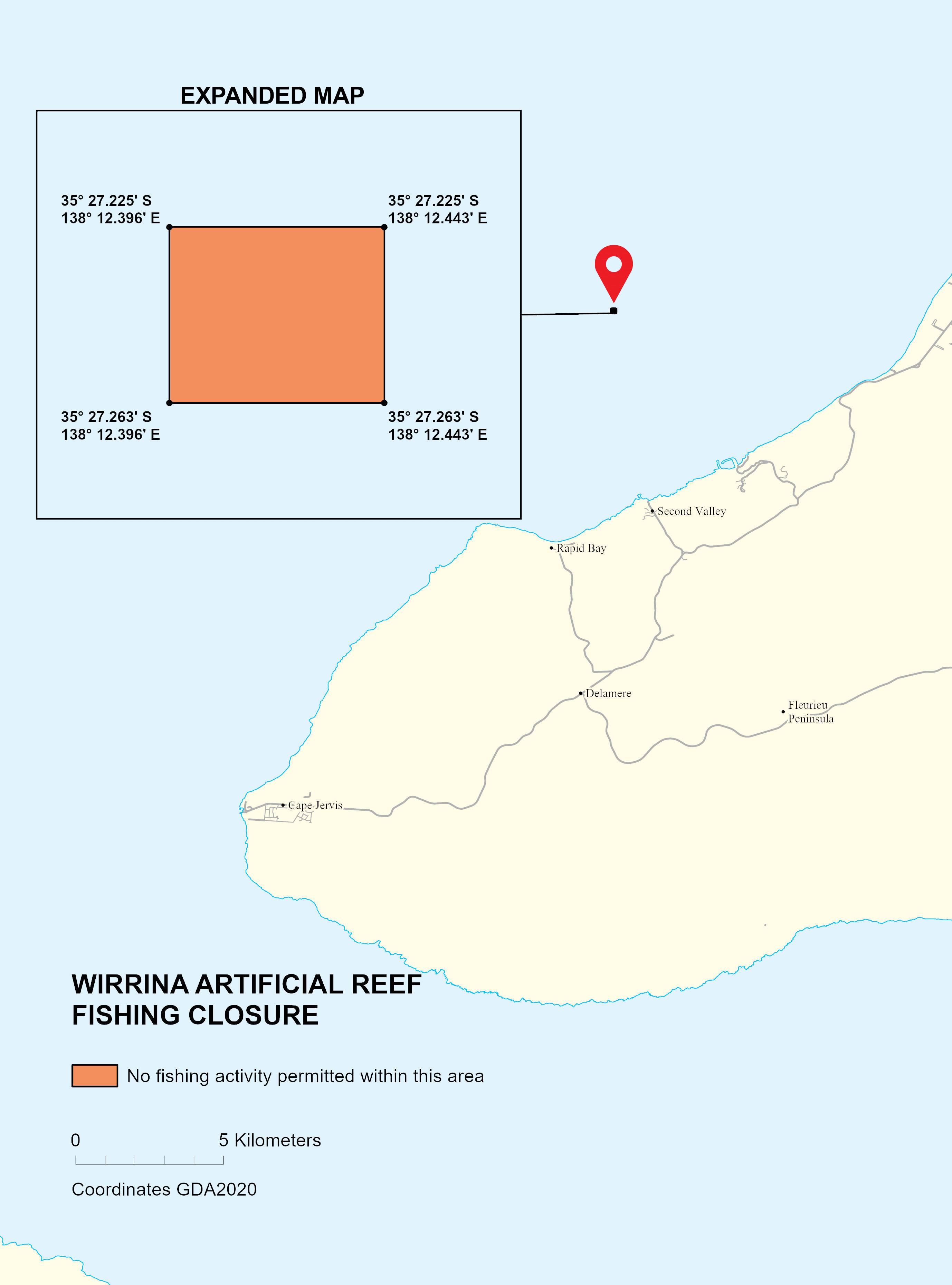
The Wirrina artificial reef will provide habitat for important recreational species and enhanced recreational fishing opportunities in the future.
All fishing is temporarily prohibited from 25 May 2026 for 12 months while the reef establishes:
- no fishing activity of any kind, including line fishing, crab netting and spearfishing
- no collection or removal of any bottom dwelling organisms such as oysters, seaweed, crabs or other shellfish.
Boating and diving is permitted.
The closure area is 70 metres by 70 metres, bounded by these points:
- 35° 27.225' S, 138° 12.396' E
- 35° 27.225' S, 138° 12.443' E
- 35° 27.263' S, 138° 12.443' E
- 35° 27.263' S, 138° 12.396' E
Permanent fishing closure
You must not fish in the waters off the coast of Wirrina Cove (Fleurieu Reef).
It is bounded by a circle radius of 0.5 of a nautical mile around the point:
- latitude 35°28.9’S
- longitude 138°09.5’E.
Species closures
Species closures may be in place for sustainability purposes, or as a precautionary health and safety measure.
Closure of Southern Zone abalone fishery
Due to the spread of AVG and depleted abalone stocks, from 5 pm on Thursday 6 March 2025, the take of any abalone (commercial or recreational) is prohibited from the River Murray Mouth to the Victorian Border.

Commercial and recreational fishers cannot move equipment that has come into contact with the sea floor in the Southern Zone – waters adjacent to South Australia east of the meridian of longitude 139° East – to other waters without full decontamination.
See Abalone viral ganglioneuritis for more information.
Intertidal reefs
Permanent closure
Intertidal reefs are those rocky areas of our coastline extending up to the high tide mark.
It is illegal to remove any bottom dwelling organisms from any intertidal rocky reef in South Australia out to a depth of 2 m.
This includes:
- abalone
- barnacles
- coral
- crabs
- limpets
- mussels
- sea urchins
- shrimps
- snails
- worms.
Learn more about protecting intertidal reefs ( ).
Aquatic reserves
You must not take abalone from any aquatic reserve in South Australia.
Fishing limits
Daily fishing limits apply to taking Blacklip and Greenlip Abalone in permitted areas.
Bait
You cannot use abalone for bait or berley in South Australian waters.
Port River system and surrounding waters (from West Lakes to Port Gawler, including Section Bank)
Permanent closure
You cannot take any bivalve shellfish (bivalve molluscs) from the Port River system and surrounding waters under further notice.
This includes:
Fishing limits
Daily fishing limits apply to taking bivalve shellfish in permitted areas.
Discover the fishing limits for bivalve species in the fishing limits search.
Seasonal closure: 1 August to 31 January (inclusive)
Fishing and possession of Black Bream is not permitted in the Lakes and Coorong during the closure period.
This temporary closure is to protect the spawning aggregation of Black Bream.
There is an additional closure for all netting within 300 m of barrages located in the Coorong (Area 1) – see the map of the barrages in Coorong ( )
Fishing limits
Daily fishing limits apply to taking bream in permitted areas.
Annual closure: 1 September to 30 November (inclusive)
You cannot fish for bream in the Onkaparinga River upstream of the Main South Road Bridge at Noarlunga during closure times.
Fishing limits
Daily fishing limits apply to taking bream in permitted areas.
Permanent Cephalopod Exclusion Zone
You must not target or take cephalopods from False Bay, Spencer Gulf, within the waters north of:
- the lighthouse at Point Lowly to the southern end of the Point Bonython jetty
- south-west to the eastern most point of the BHP Jetty:
- latitude 33°02’12.63”S
- longitude 137°36’1.98”E
- then following a high water mark at the base of the jetty along the shoreline back to the Point Lowly lighthouse.
Permanent cuttlefish fishing closure
Following a temporary closure in 2022–23, from 1 May 2023 a permanent cuttlefish fishing closure is in place in the waters of Upper Spencer Gulf.
You must not target or take any cuttlefish species in the waters north of a line from:
- the Mean High Water Springs closest to 33°55’39.892”S 136°34’20.163”E (near Arno Bay), to
- the Mean High Water Springs closest to 33°55’39.896”S 137°37’14.557”E (Wallaroo Jetty).
Closure map
View the map of cephalopod fishing closure area ( ).
Fishing limits
Daily fishing limits apply to taking cephalopods in permitted areas.
Discover the fishing limits cephalopods species in the fishing limits search.
Port Pirie zone 1 – South area of Germein Bay, including First Creek, Second Creek, Port Pirie River, and Shag Creek
You must not take the following species from this area:
- crabs
- razorfish
- mussels.
Permanent fishing closure for certain species
These closures apply to recreational fishing, to reduce community exposure to heavy metals. The advice does not apply to commercially caught seafood outside the 2 closure zones, adjacent to the town and estuary area.
These closures supersede the temporary bans imposed in September 2020.
For more information about the health risks of recreational fishing in Port Pirie, visit Fishing | SA Health.
All bottom dwelling organisms
Permanent closure
Intertidal reefs are those rocky areas of our coastline extending up to the high tide mark.
It is illegal to remove any bottom dwelling organisms from any intertidal rocky reef in South Australia out to a depth of 2 m.
This includes:
- abalone
- barnacles
- coral
- crabs
- limpets
- mussels
- sea urchins
- shrimps
- snails
- worms.
Learn more about protecting intertidal reefs ( ).
A spawning closure applies to the targeting, take, and possession of King George Whiting in Gulf St Vincent and Spencer Gulf from 1 March until 30 June.
.
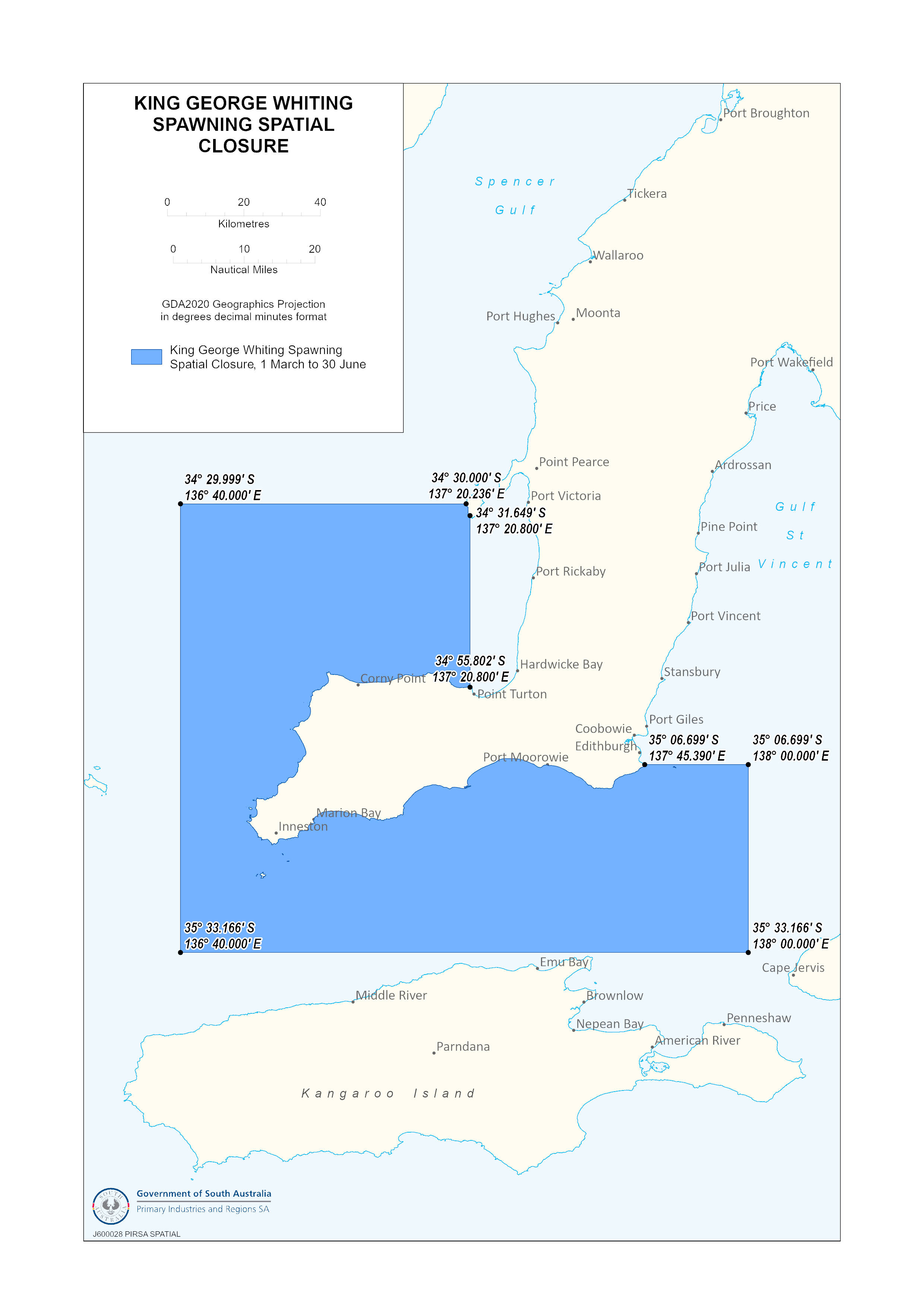
Download the King George Whiting spawning closure map ( ).
Permanent closure
You must not take Murray Cod at any time within:
- River Murray proper
- Lake Albert
- Lake Alexandrina.
This excludes the waters of the Coorong.
Catch and release only from 1 January to 31 July
You can catch and release Murray Cod between 1 January to 31 July each year in:
- River Murray proper, excluding the Chowilla floodplain north of the River Murray between 34°9'46.65" South, 140°45'30.41" East (Ral Ral Creek) upstream to the River Murray at 34°1'14.55" South, 141°0’9.72" East (South Australia and New South Wales border) – see Murray cod closure map ( )
- Lake Albert
- Lake Alexandrina, excluding the waters of the Coorong.
Catch and release of Murray Cod is permitted all year round when reservoir fishing.
See the safe catching and handling practices as well as how to release your catch.
Port River system and surrounding waters (from West Lakes to Port Gawler, including Section Bank)
Permanent closure
You cannot take any bivalve shellfish (bivalve molluscs) from the Port River system and surrounding waters under further notice.
This includes:
Port Pirie zone 1 – South area of Germein Bay, including First Creek, Second Creek, Port Pirie River, and Shag Creek
You must not take the following species from this area:
- crabs
- razorfish
- mussels.
Permanent fishing closure for certain species
These closures apply to recreational fishing, to reduce community exposure to heavy metals. The advice does not apply to commercially caught seafood outside the 2 closure zones, adjacent to the town and estuary area.
These closures supersede the temporary bans imposed in September 2020.
For more information about the health risks of recreational fishing in Port Pirie, visit Fishing | SA Health.
Intertidal reefs
Permanent closure
Intertidal reefs are those rocky areas of our coastline extending up to the high tide mark.
It is illegal to remove any bottom dwelling organisms from any intertidal rocky reef in South Australia out to a depth of 2 m.
This includes:
- abalone
- barnacles
- coral
- crabs
- limpets
- mussels
- sea urchins
- shrimps
- snails
- worms.
Learn more about protecting intertidal reefs ( ).
Port River system and surrounding waters (from West Lakes to Port Gawler, including Section Bank)
Permanent closure
You cannot take any bivalve shellfish (bivalve molluscs) from the Port River system and surrounding waters under further notice.
This includes:
This closure is in place to reduce the risk of spreading the Pacific Oyster Mortality Syndrome (POMS) virus.
The Younghusband Peninsula (Coorong Beach)
Permanent closures
The Younghusband Peninsula (Coorong Beach) is a commercial fishing zone only.
You must not take Pipi in this area between Murray Mouth and 28 Mile Crossing.

Statewide
Annual seasonal closure from 1 June to 31 October.
You must not take Pipis from any area or waters within South Australia during this closure period.
Fishing limits
Daily fishing limits apply to taking Pipis in permitted areas.
Permanent species closure
You must not take prawns at any time from any South Australian waters less than 10 m deep.
Upper Spencer Gulf
Seasonal closure from 1 October to last day of February inclusive (the following year)
You must not take Razorfish from Upper Spencer Gulf between Commissariat Point and Blanche Harbour during the closure period.
Port River system and surrounding waters (from West Lakes to Port Gawler, including Section Bank)
Permanent closure
You cannot take any bivalve shellfish (bivalve molluscs) from the Port River system and surrounding waters under further notice.
This includes:
Port Pirie zone 1 – South area of Germein Bay, including First Creek, Second Creek, Port Pirie River, and Shag Creek
You must not take the following species from this area:
- crabs
- razorfish
- mussels.
Permanent fishing closure for certain species
Port Pirie zone 2 – North area of Germein Bay
You must not take razorfish from this area.
These closures apply to recreational fishing, to reduce community exposure to heavy metals. The advice does not apply to commercially caught seafood outside the 2 closure zones, adjacent to the town and estuary area.
These closures supersede the temporary bans imposed in September 2020.
For more information about the health risks of recreational fishing in Port Pirie, visit Fishing | SA Health.
Fishing limits
Daily fishing limits apply to taking razorfish in permitted areas.
Moving rock lobster pots
Commercial and recreational fishers cannot move equipment that has come into contact with the sea floor in the Southern Zone – waters adjacent to South Australia east of the meridian of longitude 139° East and shallower than 30 metres – to other waters without full decontamination. See Abalone viral ganglioneuritis for requirements.
Northern zone seasonal closure
From 6:00 pm 31 May to 12 noon 1 November
You must not take rock lobster from the northern zone. This area extends from west from longitude 139°0’4.80” to the Western Australian border.
View the northern zone closure area on the map ( ).
Southern zone seasonal closure
From 6:00 pm 31 May to 6:00 am 1 October
You must not take rock lobster from the southern zone. This area extends from east from longitude 139°0’4.80” to the Victorian border.
View the southern zone closure area on the map ( ).
Permanent species closure
Rock lobsters are completely protected at all times within rock lobster sanctuaries.
A maximum penalty of $35,000 applies to taking rock lobster within these protected areas.
Cape Jaffa Rock Lobster Sanctuary
Learn more about the sanctuary and view on the map. ( )
View the sanctuary boundary points in Google Maps.
Margaret Brock Reef Rock Lobster Sanctuary
Learn more about the sanctuary and view on the map. ( )
View the sanctuary boundaries in Google Maps.
Gleeson's Landing
Learn more about the sanctuary and view on the map. ( )
View the sanctuary boundaries in Google Maps.
Rivoli Bay Rock Lobster Sanctuary
Learn more about the sanctuary and view on the map. ( )
Port McDonnell Breakwater
Learn more about the sanctuary and view on the map ( )
Fishing limits
Daily fishing limits apply to taking rock lobster in permitted areas.
West Coast, Spencer Gulf, Gulf St Vincent and Kangaroo Island fishing zones
Total species closure until 30 June 2027.
Snapper fishing closures are in place to help Snapper stocks recover.
The targeting, take and possession of snapper is prohibited in closed waters.
You must not transit through a Snapper closure area if you have legally caught Snapper on board. This means it is prohibited to bring Snapper back to any boat ramp in a closed area, such as Cape Jervis, Wirrina and Penneshaw.
Fines and penalties may apply.
Closures
View the Snapper closure area on the map ( ).
Fishing limits
Find out the daily fishing limits for Snapper in South East waters.
A total closure is in place from 1 May 2026 prohibiting the targeting, take and possession of Southern Calamari in the Spencer Gulf and Gulf St Vincent and Kangaroo Island fishing zones for recreational and charter boat fishing.
A closure is place from 1 May 2026 prohibiting the targeting, take and possession of Southern Garfish in the Gulf St Vincent and Kangaroo Island fishing zone for recreational and charter boat fishing.
Port River system and surrounding waters (from West Lakes to Port Gawler, including Section Bank)
Permanent closure
You cannot take any bivalve shellfish (bivalve molluscs) from the Port River system and surrounding waters under further notice.
This includes:
Fishing limits
Daily fishing limits apply to taking Vongole in permitted areas.
Permanent closure
You cannot fish for Western Blue Groper at any time in:
- Spencer Gulf
- Gulf St Vincent
- Investigator Straight
- Backstairs Passage.
This includes all waters north from a line from:
- Newland Head to Cape Willoughby
- West Bay to Cape Carnot on southern Eyre Peninsula.
View the Blue Groper closure area on the map ( )
Fishing limits
Daily fishing limits apply to taking Western Blue Groper in permitted areas.
Gear restricted areas
There are restrictions to the gear you can use in certain waters. Penalties can apply if you do not follow the rules in closure areas.
Within the inner waterways of the Port Adelaide River system, southeast of a line from Pelican Point to the southern breakwater at St Kilda, it is not permitted to:
- use a fishing line (hand line or rod) within 50 metres of a visible dolphin
- use hooks with a shank length greater than 56 mm and a gape greater than 23 mm.
View the map of the impacted area ( ).
Areas of the Adelaide Dolphin Sanctuary are located within the Barker Inlet – St Kilda Aquatic Reserve where additional restrictions apply – see gear restricted areas.
Line fishing only
You can only use the below fishing gear in the reserve:
- fish using a rod and line or handline
- collect bloodworms using a hand net.
You are strictly prohibited from:
- collecting or removing any marine organism other than a fish
- crabbing or using a crab net.
You must not use any other fishing gear. A maximum penalty of $20,000 applies.
Closure area
View the closure area on the map ( ).
Areas of the Barker Inlet – St Kilda Aquatic Reserve are located within the Adelaide Dolphin Sanctuary where additional restrictions apply – see Gear restricted areas.
Line fishing only
Inside the reserve you are restricted to only:
- fish using a rod and line or handline
- collect bait from the shore.
Learn more about permitted activities and view the reserve map ( ).
Mesh net use restrictions
You can only use mesh nets with an existing registration in the Coorong. New registrations are no longer available for mesh net use in:
- the Coorong
- Lake Albert
- Lake Alexandrina.
You can apply to register or renew registration for mesh net use in Lake George only.
Mesh net closures
There are restrictions on the use of mesh nets in some areas of the Coorong.
The waters of the Coorong are divided into Area 1 and Area 2 – see the Lakes and Coorong recreational fishing mesh net areas map ( ).
Area 1
Seasonal closure: 1 November to 31 March inclusive – you cannot use a mesh net between the closure dates each year.
All netting within 300 m of barrages located in the Coorong Area 1 is not permitted for Black Bream fishing.
Area 2
Mesh net use permitted – you can use a registered mesh net in Area 2 at all times of the year.
Goolwa channel
You cannot use a mesh net from midnight Friday to midnight Sunday, between Goolwa barrage and the Goolwa channel.
The Goolwa channel extends from:
- A.G.A. light on Mundoo Island across to Hindmarsh Island
- upstream to the south east corner of Allotment 109, section 601 Hundred of Nangkita
- across the Murray Mouth to Younghusband Peninsula then back to the A.G.A. light.
Permanent closures
You cannot use a mesh net within:
- 150 m of all barrages
- 100 m of any jetty, pier or wharf.
The use of rock lobster pots is temporarily prohibited until 24 July 2026 in the waters near the area known as the Granites – see map of closure area ( ).
Rock Lobster may be taken by other permitted means within the closure area.
Mesh net use restrictions
You must register mesh nets before use.
Apply to register or renew registration for mesh net use in Lake George.
Mesh net closures
You cannot use mesh nets in the Lake George closure areas:
- the Lake George Southern Lagoon
- the drainage channel connecting Lake George to Tivoli Bay
- any other waters that feed into Lake George.
Permitted gear
You are allowed to:
- line fish in the closure area
- use registered mesh nets in the open waters in Lake George.
Permanent closures
You cannot use mesh nets within:
- 100 m of any jetty, pier or wharf
- 150 m of all barrages.
Mesh net use restrictions
You can only use mesh nets with an existing registration.
New registrations are no longer available for mesh net use in:
- the Coorong
- Lake Albert
- Lake Alexandrina.
You can apply to register or renew registration for mesh net use in Lake George only.
Daily fishing gear restrictions
Daily restrictions apply from 5 am to 9 pm from the southernmost breakwater at Outer Harbor to Lady Bay Shacks, south of Normanville, from Mean High Water Springs to a distance of 500 metres seaward.
During these times you cannot use:
- any wire trace
- a monofilament trace exceeding 1 mm in diameter
- hooks with a length greater than 56 mm or a gape greater than 23 mm
- combination or gang of hooks joined by threading the point of one through the eye of another.
View the restriction area on the map ( ).
Statewide restrictions on hook size and trace size
At all other times and anywhere in South Australia you cannot use the following gear together:
- wire trace with a gauge of 2 mm or greater
- fishing hooks of size 12/0 or greater.
Find out more about fishing for sharks and rays.
Line fishing and hand nets only
You can fish for:
- fish using a handline or rod and line
- shrimp using a hand net.
No other fishing gear is permitted in these waters.
Line fishing only
You can fish using a handline or rod and line.
You cannot use any other fishing gear in these waters.
Shore-based line fishing closures
Restrictions apply to shore based line fishing in the Far West Coast at different times of the year.
For more Far West Coast marine park information visit the National Parks and Wildlife Service South Australia website
Commercial and recreational fishers cannot move equipment that has come into contact with the sea floor in the Southern Zone – waters adjacent to South Australia east of the meridian of longitude 139° East – to other waters without full decontamination. See Abalone viral ganglioneuritis for requirements.
Diving equipment includes: wetsuits, fins, masks, weight vests and belts, hookah gear and diving accessories including but not limited to knives, bags and nets.
Fishing equipment includes but is not limited to: rods, reels, lines, hooks, sinkers, lures, jigs, bins, baskets, buckets, nets, pots, bags, spearguns and knives.
You must not fish using a hand fish spear or spear gun in the areas below.
Statewide
You cannot spearfish within 100 m of all:
- jetties
- landings
- wharves including the adjacent foreshore areas.
Hindmarsh and Inman River mouths
You cannot spearfish within 200 m of the Hindmarsh and Inman River mouths.
Gulf St Vincent
You cannot spearfish within 600 m of the high water mark from:
- 100 m immediately south of the southernmost Outer Harbor breakwater to the southernmost point of the southern car park of Kingston Coastal Reserve
- the southernmost point of the Balboa Drive Carpark, Hallett Cove to Witton Bluff
View the closure area on the map ( ).
Second Valley
You cannot spearfish in the waters of Second Valley Bay (PDF 185.1 KB) ( ).
Port Noarlunga Sanctuary Zone
You cannot spearfish in the Port Noarlunga Sanctuary Zone. This area was formerly known as the Port Noarlunga Aquatic Reserve.
Line fishing and crab fishing restrictions
Fishing gear restrictions apply inside the St Kilda - Chapman Creek Aquatic Reserve.
You can:
- only take blue swimmer crabs by hand, crab rake or hoop net
- land-based line fishing on the the northern side of the breakwater.
The following is not permitted:
- bait digging
- fishing (other than land-based line fish from the breakwater)
- collecting or removing any marine organism (other than blue swimmer crabs).
Penalties apply to prohibited activities.
Learn more about permitted activities and view the reserve map ( )
Line fishing only
You can only fish the Troubridge Hill Aquatic Reserve using rod and line or handline.
You cannot use any other fishing devices or gear in this area.
Learn more about the permitted activities and view the reserve map ( ).
Line fishing only
You can only fish in the West Island Aquatic Reserve Area 1 using a rod and line or handline.
You cannot use Rock Lobster pots or any other fishing gear in this area.
There is strictly no entry in Area 2 of the reserve.
Learn more about permitted activities and view Areas 1 and 2 on the reserve map. ( )