
Crop management imagery – Green Brain
Satellite monitoring at the vine-row level, identifying underperforming areas to help manage crop health.
Benefits
Green Brain gives a clear visualisation of differences in crop vigour, earlier than the human eye can see. This is useful in blocks characterised by variability in soil type and slope.
Informed decisions can be made to:
- maximise yield
- save on water and fertiliser costs
- predict disease risk.
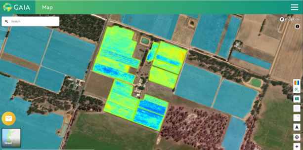
High-resolution satellite imagery showing variation in crop vigour on the Green Brain dashboard
How it works
Green Brain uses satellite imagery to remotely detect crop issues and lost productivity at the vine-row level. This includes areas of underwatering or overwatering.
Satellite imagery is updated every 2 weeks, enabling crop vigour to be tracked over time. All data is easily accessible on the Green Brain web-app.
Green Brain also integrates with third-party software for irrigation scheduling and farm management.
Installation and power
No installation required.
Connectivity requirements
The platform is web-based and accessible on desktop and mobile devices.
Pricing model
Annual subscription.
See it in action
To view the Green Brain package, contact the AgTech Extension Officer at Loxton demonstration farm.
Contact vendor
Dominic Skinner
Email: dominic@greenbrain.ag
Mobile: 0438 507 320
Adam Brown
Email: adam.brown@greenbrain.ag
Mobile: 0411 276 244